
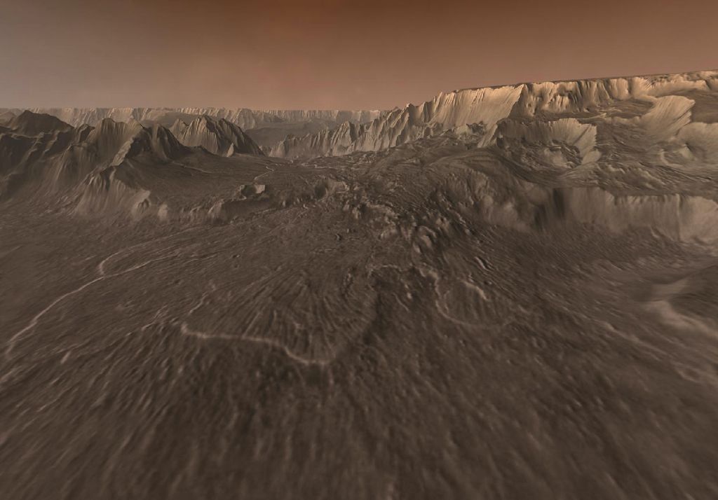

On the planet Mars, the water has left undeniable traces over the millennia of its past presence. The Martian surface is rich in large networks of canyons and canals, now dry, which branch from the Martian highlands, all dug by water during a long erosion process and leading to lakes and perhaps even to an ocean.
The Narochian period is a phase of the life of the planet characterized by a high frequency of impacts of meteorites and asteroids and by the possible presence of water in abundance on the surface of Mars.
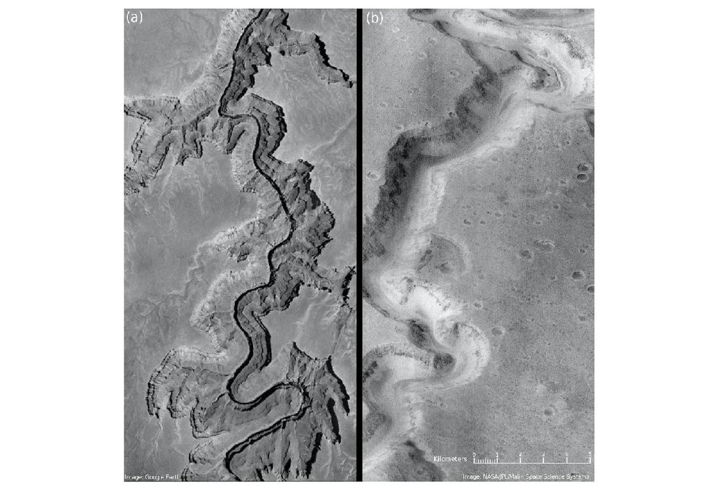
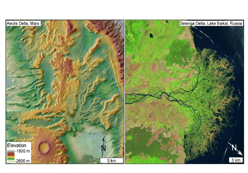
The Rover Perseverance of NASA is currently exploring a crater basin, the Jezero crater, which was the site of an old Noé river which deposited large quantities of debris, forming a delta similar to those found on earth.
The mystery remains As for the reason why Mars was a hot and wet planet for a relatively short period (thousands or millions of years), as well as the water that has eroded its surface.
Two scenarios opposed for the red planet
If the presence of water is obvious, its origin remains a mystery. According to some researchers, Mars experienced hot and humid periods, Characterized by abundant rains and snowfalls that have shaped its soil.
Others think that the planet has always been cold and dry, as we know it today, with layers of ice that found occasionally, generating temporary water rivers that shaped the soil.
New elements for the solution (not yet definitive) of this mystery come from research carried out by a team of geologists from the University of Boulder in Colorado (USA).
The results were presented in the Journal of Geophysical Research: Planets in an article led by Amanda Steckel.
IT simulations promote rain and snow
The researchers used software developed to study the earth’s crust and adapted it to Martian soil. This software simulates, or rather models, a small part of the Martian surface near the equator.
It is in fact a question of reproducing a soil having the same characteristics as that of Mars and of making it evolve in time.
-The research group considered two different scenarios. In the first scenario, He examined the effect on the water from the water from possible precipitation and snowfall. In a second scenario, they took into account the effect of the erosion of the soil caused by the cast iron of the polar caps.
In the two simulated scenarios, The researchers let the water flow for tens or hundreds of thousands of years. The terrain shaped by the flow of water was compared to the real terrain observed today by the Spatial probes Mars Global Surveyor and Mars Odyssey, as well as by Martian Rovers.
The two simulations have given very different results
The two simulations have given very different results, Let’s see which ones.
Erosion due to the melting of glaciers
In the case of the melting of the glaciers, the sources of water which then dug the valleys for thousands of years On the high altitude, precisely along the old high altitude glaciers, were formed, as high altitude.
Erosion by rainwater and snow
In the case of rainwater or snow, this being much more widely distributed at all altitudes, Sources are formed at more varied altitudes, ranging from an altitude below the average altitude up to 3,300 meters above sea level.
Stekel himself says: “The water contained in the ice layers only begins to form valleys out of a narrow altitude strip. On the other hand, if the precipitation is distributed, the valleys can form anywhere.
The results of the simulations indicate that the current conformation of the Martian soil is better reproduced if we suppose the presence of rains whose water has eroded Martian soil during the millennia.
We still do not know how Mars managed to maintain a sufficiently high temperature To have a water cycle similar to that of the earth.
The most widely accepted hypothesis is that of a strong greenhouse effect in the primordial Martian atmosphere. Indeed, once he has stopped raining on Mars, his surface was crystallized for the following 3 billion years, exactly as we see it today.
Article reference:
“Landscape Evolution Models of Incision on Mars: Implications for the Ancient Climate” A. V. Steckel et al. JGR Planets, 2024


