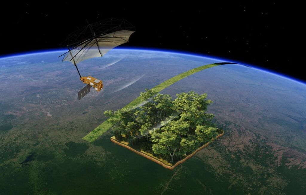
It was placed in orbit on Tuesday morning, by the small Italian rocket Vega-C, launched by Arianespace from the space base of Kourou, in Guyana. The biomass scientific satellite of the European space agency presents itself as a real technological rupture in the science of earth observation.
Biomass is indeed the first satellite equipped with a high wavelength radar, capable of penetrating the forest canopy to measure “biomass” – the trunks, branches and woody stems, where trees store most of their carbon.
20 Minutes Asked Dominique Gilliéron, head of earth observation projects at ESA, to tell us about this revolutionary program.
How was the launch of the biomass satellite by the Vega-C rocket?
The precision of the VEGA-C rocket was remarkable since it placed the satellite on its ideal orbit, located 666 km from the earth. This is very important for its longevity, because the quantity of ergol for the propulsion of the satellite is limited, and we therefore did not have to consume it too much from the start to move it. Since the night from Tuesday to Wednesday, we verify that the satellite has perfectly survived the launch, knowing that it is a fairly traumatic event during which it is extremely shaken. We first checked if he communicates with the ground, which is the case, then if he deploys his solar panels and if he has electricity, which went well too, and finally if it is stabilized, which is done. The next big step, which will last eight days, is the deployment of its huge umbrella [un réflecteur de 12 mètres de diamètre]which will be done little by little, because it is a very sensitive operation.
Biomass has been designed to provide information on the role of forests in the terrestrial carbon cycle. Concretely, what does that mean?
The aim of the mission is to precisely measure the quantity of sequestered carbon in tropical forests, because we have between 10 and 20 % of uncertainties on this quantity. When we know that forests represent about 8 billion tonnes of sequestrated carbon per year, including 45 % by tropical forests, this difference can have an impact on long -term forecasting models of the climate.
In addition, we want to determine the consequences of deforestation on this gigantic carbon wells, and how these forests evolve thanks to climate change. The evolution of temperatures and rainfall increases the quantities of CO2, does that in reaction tropical forests capable of storing carbon more quickly-which would mean that they play a global warming effect-or, on the contrary, this upheaval is stressing the forest, to the point that it would be less able to store carbone than before?
Why does the mission only observe tropical forests?
For a large number of forests, especially those that are at our latitudes, measures are already made via other satellites, such as Sentinel 1 and 2. There are also a whole series of ground controls, as well as in France by the National Forest Office. The problem with tropical forests is that they are forests with dense foliage, through which current systems do not see. However, only 1 % of carbon is kidnapped in the foliage, so you have to go to see below. We could go there to measure this, but we speak of an absolutely gigantic surface, in unsuccessful areas … So we are forced to do so from space to have a global vision, and with a new type of satellite, which is the case with this penetrating radar which is a world first to look at the earth.
What is so special?
What is unique is that it is a Radar satellite in a P band, which means a very long wavelength, which will be sensitive to 70 cm dimension objects, but which will ignore everything that is smaller. So he doesn’t see [ou peu] The foliage, it crosses it, to directly measure the branches and trunks of the trees, in areas of about 200 meters by 200 meters. These are the measures that will deduct carbon storage capacities.
How will the mission take place, and how long will it last?
We should obtain our first radar image within a month, then we will enter a calibration phase, with a series of measures around 50 test sites distributed in the world, to be sure that our satellite restores good values. After six months, we can start to provide the first validated data to scientists on the first tropical forests. The mission is calibrated to last five years, but we can undoubtedly extend it for a few years.
The satellite will not only measure the forests during this time, it will also be interested in other environments, what to do?
Yes, it will be the secondary missions of this scientific program, which will observe the basements of dry deserts, up to five meters deep. This will interest geologists and archaeologists, because we could detect under the sand of old cities today buried. He can also penetrate around 40 to 50 meters into the ice, which is important to measure the melting of the ice cap.
How long did it take to carry out this project?
We speak in decades. The first scientific concept was formulated before the 2000s, but the technologies to make a satellite of this class were then not available. It was only from 2013 that ESA and its member states decided to transform these studies into a scientific mission. French laboratories such as CESBIO (Center for Spatial Studies of the Biosphere) of the University of Toulouse, English laboratories, worked on this project, then fifty European manufacturers worked on the design of the satellite.
Our file on space
It is really a European project, these kinds of missions would be impossible to carry out for a single country. And this is the goal of the European Space Agency, to advance science in the field of earth observation, to have data on the evolution of the planet, which is absolutely crucial to prepare for the future.


